
Dogtra Pathfinder GPS Track & Train System
Description
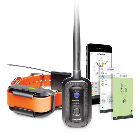
The Pathfinder works without using cellular data -- download the free Dogtra Pathfinder app to your phone and add free offline maps, then you can smartphone to track the dog in offline map mode The new Dogtra Pathfinder GPS Dog Tracking N Training System is finally here. This dog tracker brings GPS and e-collar 2 in 1 feature right to your smartphone with IOS or Android operating system. It is giving you an easier way to track and train dogs. The Pathfinder works without using mobile phone data. Download the free maps to your phone (while you have WIFI available) and operate your smartphone in offline map mode. Unlike other GPS e-collars, you can enjoy the tracking on a more refined, higher resolution and bigger mobile screen. How does it work? The Dogtra Pathfinder uses your smartphone as handheld tracking device. Pathfinder connector acts as an intermediate which connects your smart phone and dog tracking collar together. It connects with Smartphone via Bluetooth and Dog Tracking Collar via Radio signal. You will be using Google Maps™ offline version with standard, satellite and terrain views from your smartphone. The Dogtra Pathfinder smartphone app allows you to track up to 21 dogs or hunters, share locations with other hunters, playback tracking data history and create custom Geo-Fence notifications. With super fast two-second update rate and a powerful zoom in capacity, the Pathfinder tracking feature has greater live action detail and very accurate location information when you’re out hunting.  Maps Available for download and use Google Map ‫ NormalGoogle Map ‫ SatelliteGoogle Map ‫ TerrainOffline Maps ‫ OutdoorsOffline Maps ‫ Google NormalOffline Maps ‫ Google SatelliteOffline Maps ‫ Google TerrainOffline Maps ‫ Custom Maps For live data without downloading any offline maps, you can only use Google Maps in Normal (street only), Satellite (True view) and Terrain (with Contour lines and Topographic view in low details) If you need more details of the area combine with contour lines and topographic, you will have to use Offline Maps - Outdoors. This map gives you terrain contours and summit points at 10 metres intervals with 3-D shading which is the same as Garmin Topo Full Map. The Dogtra Pathfiner app allows you to download max 400MB of Google Map data onto your smartphone device. If you need to hunt in a few different area, you can download different area maps when you Internet Connection before you for the Hunt (offline). You can download as many maps as you need. The max size of each download is 400MB but you can easily merge a few maps to cover a bigger area. The downloaded area will be highlighted in BLUE and select download area will be in GREEN. You can select overlapping part of existing area to extend the coverage. All the Maps are downloaded to your smartphone device internal memory within the Dogtra Pathfinder APP. So if you have a smartphone with bigger internal storage, you can download more maps. For android users, you can copy the APP to SD card of the phone or make the SD card as internal storage for Android Marshmallow system to give more storage space for the MAP data. Package includes Dogtra Pathfinder GPS/ Ecollar Dogtra GPS "Connector" Belt clip and lanyard Charger and splitter charging cable E-collar stimulation test light  Dogtra Pathfinder “Connector†On/off button Connects to smartphone via Bluetooth with max range of 10 metres Fully waterproof (IPX 7) Battery power indicator Fast charge lithium polymer battery  Dogtra Pathfinder “Dog Collar†Suits dogs from 15kg On/off button F


