
Garmin Alpha 200i GPS Handheld Only with inReach
Description
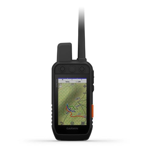
Other Features: Measures dogs’ speed and distance travelled Dog Trails: Choose from three views: Complete History, Partial History, or no Trail History Map Screen option: Show / Hide Dog’s Status, Distance, Names, and Off screen Dogs Zoom to MAP DOGS - automatically zoom in/out to include all dogs appear on the map screen -- no matter how far they are from you Wireless sharing of Dog info to other ALPHA handheld units 16GB internal memory - install extra maps Expandable external memory by micro SD card Comes with Australian Topactive Map BirdsEye direct to device without annual subscription required Waterproof Rechargeable with user replaceable battery Trip Computer The Garmin Alpha 200i GPS dog tracking handheld is the new addition to the touchscreen Alpha Range product. It is compatible with Garmin T5x / T5 mini collar for tracking as well as TT15x /TT15 mini collar for tracking and training. It has new larger 3.5 inch capacitive touchscreen which is a sunlight-readable touchscreen. The improved 6 button design is great for fast training cues and minor adjustments in the field. One of the main feature of the Alpha 200i is built in inReach Iridium satellite technology. It allows you communicated with your friends, love ones or event post on social media websites without using traditional mobile network. Always connected with inReach Iridium satellite technology TWO-WAY MESSAGING Exchange text messages with loved ones, post to social media, or communicate inReach to inReach in the field (satellite subscription required). INTERACTIVE SOS In case of emergency, trigger an interactive SOS message to GEOS, a professional 24/7 global monitoring and response centre (satellite subscription required). LOCATION SHARING Track your location, and share it with those at home or out in the field so they can see your progress or ping your device for your GPS location and more (satellite subscription required). 100% GLOBAL IRIDIUM® SATELLITE NETWORK Instead of relying on mobile coverage, now your messages, SOS alerts and tracking are transferred via the global Iridium satellite network (satellite subscription required). GeneralPhysical dimensions: (6.8 x 16.2 x 3.4)Weight: 280g with standard antenna and batteryWater rating: IPX7Battery type: rechargeable lithium-ion (included)Touchscreen: YesDisplay type: Transflective, colour TFT touchscreenDisplay size: 4.7 W x 7.7 H cm; 3.5 inch diag (88.9 mm)Battery life: up to 20 hours; up to 15 hours with inReach® technology enabledMemory/history: 16.0 GBHigh-sensitivity receiver: YesInterface: USBMaps & MemoryBasemap: yesPreloaded maps: yes (topographic active)BirdsEye: Yes, direct to device (no annual subscription required) Ability to add maps: yesAccepts data cards: microSD™ card (not included)Custom POIs (ability to add additional points of interest): yesWaypoints/favorites/locations: 10000Routes: 250Track log: 20,000 points, 250 saved tracksSensorsBarometric altimeter: yesCompass: Yes (tilt-compensated 3-axis)Outdoor Recreation FeaturesArea calculation: yesAutomatic routing (turn by turn routing on roads): Yes (with optional mapping for detailed roads)Custom maps compatible: yesHunt/fish calendar: yesSun and moon information: yesGarmin Connect™Garmin Connect™ compatible (online community where you analyze, categorize and share data): yes Garmin inReach devices require satellite subscription activation to function. The service provided is an inReach two-way satellite communicator service, which uses the Iridium low orbit satellite network together with inReach customer equipment, which is sold separately. Customers can use the satellite service to send and receive text messages to a cell phone (SMS) number or email addre


