
Garmin Alpha 300i Handheld Only
Description
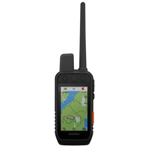
Other Features: Vivid sunlight-readable 3.5†capacitive touchscreen display Track N Train up to 20 dogs with your compatible dog collars Lasts up to 55 hours per full charge Dog list and group management to keep non-paired dog information Preloaded TopoActive maps Downloadable satellite imagery from Wifi Built-in 3-axis compass and barometric altimeter. With an Outdoor Maps+ subscription, you have access to a wide variety of premium mapping content that is regularly updated and wirelessly delivered directly to your Alpha® 300 handheld when connected to a wireless network. User-replaceable battery lasts up to 55 hours. Triggers 18 levels of stim, tone or vibration when paired with your training-enabled collar. Compatible with the Garmin Explore & smartphone app (manage tracks, routes, waypoints and back up your device settings). The Garmin Alpha 300i is an updated model from the Alpha 200i GPS dog tracking handheld device. It has a new vivid 3.5†capacitive touchscreen display which is a lot better than the Alpha 200 under strong sunlight. The Alpha 300i has the same easily control training functions by using the button-operated, dog-focused design with Alpha 200i headheld unit. It is still offering 18 levels of static stimulation, tone or vibration when paired with TT15x and TT25 collar. The runtime of Alpha 300i handheld is also doubled from Alpha 200i which lasts up to 55 hours per full charge. Always connected with inReach Iridium satellite technology TWO-WAY MESSAGING Exchange text messages with loved ones, post to social media, or communicate inReach to inReach in the field (satellite subscription required). INTERACTIVE SOS In case of emergency, trigger an interactive SOS message to GEOS, a professional 24/7 global monitoring and response centre (satellite subscription required). LOCATION SHARING Track your location, and share it with those at home or out in the field so they can see your progress or ping your device for your GPS location and more (satellite subscription required). 100% GLOBAL IRIDIUM® SATELLITE NETWORK Instead of relying on mobile coverage, now your messages, SOS alerts and tracking are transferred via the global Iridium satellite network (satellite subscription required). GeneralPhysical dimensions: (6.8 x 16.2 x 3.4)Weight: 280g with standard antenna and batteryWater rating: IPX7Battery type: rechargeable lithium-ion (included)Touchscreen: YesDisplay type: Transflective, colour TFT touchscreenDisplay size: 4.7 W x 7.7 H cm; 3.5 inch diag (88.9 mm)Battery life: up to 55 hours; up to 50 hours with inReach® technology enabledMemory/history: 16.0 GBHigh-sensitivity receiver: YesInterface: USBMaps & MemoryBasemap: yesPreloaded maps: yes (topographic active)BirdsEye: Yes, direct to device (no annual subscription required) Ability to add maps: yesAccepts data cards: microSD™ card (not included)Custom POIs (ability to add additional points of interest): yesWaypoints/favorites/locations: 10000Routes: 250Track log: 20,000 points, 250 saved tracksSensorsBarometric altimeter: yesCompass: Yes (tilt-compensated 3-axis)Outdoor Recreation FeaturesArea calculation: yesAutomatic routing (turn by turn routing on roads): Yes (with optional mapping for detailed roads)Custom maps compatible: yesHunt/fish calendar: yesSun and moon information: yesGarmin Connect™Garmin Connect™ compatible (online community where you analyze, categorize and share data): yes Garmin inReach devices require satellite subscription activation to function. The service provided is an inReach two-way satellite communicator service, which uses the Iridium low orbit satellite network together with inReach customer equipment, which is sold separately. Customers can use the satellite serv


